 |
| |
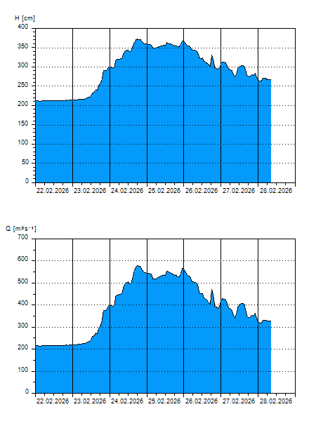
H
[cm]
|
Q
[m3.s-1]
|
QN
|
|
05.04.2026 16:00
| 161 |
125,6
|
|
|
05.04.2026 15:00
| 161 |
125,6
|
|
|
05.04.2026 14:00
| 160 |
124,0
|
|
|
05.04.2026 13:00
| 161 |
125,6
|
|
|
05.04.2026 12:00
| 162 |
127,2
|
|
|
05.04.2026 11:00
| 163 |
128,8
|
|
|
05.04.2026 10:00
| 167 |
134,8
|
|
|
05.04.2026 09:00
| 168 |
136,2
|
|
|
05.04.2026 08:00
| 166 |
133,4
|
|
|
05.04.2026 07:00
| 166 |
133,4
|
|
|
05.04.2026 06:00
| 166 |
133,4
|
|
|
05.04.2026 05:00
| 166 |
133,4
|
|
|
05.04.2026 04:00
| 166 |
133,4
|
|
|
05.04.2026 03:00
| 167 |
134,8
|
|
|
05.04.2026 02:00
| 167 |
134,8
|
|
|
05.04.2026 01:00
| 172 |
142,2
|
|
|
05.04.2026 00:00
| 172 |
142,2
|
|
|
04.04.2026 23:00
| 173 |
143,8
|
|
|
04.04.2026 22:00
| 172 |
142,2
|
|
|
04.04.2026 21:00
| 171 |
140,6
|
|
|
04.04.2026 20:00
| 171 |
140,6
|
|
|
04.04.2026 19:00
| 171 |
140,6
|
|
|
04.04.2026 18:00
| 171 |
140,6
|
|
|
04.04.2026 17:00
| 175 |
147,0
|
|
|
03.04.2026 07:00
| 186 |
165,8
|
|
|
02.04.2026 07:00
| 176 |
148,8
|
|
|
30.03.2026 07:00
| 152 |
112,8
|
|
H — water level
Q — Discharge
QN — QN |