 |
| |
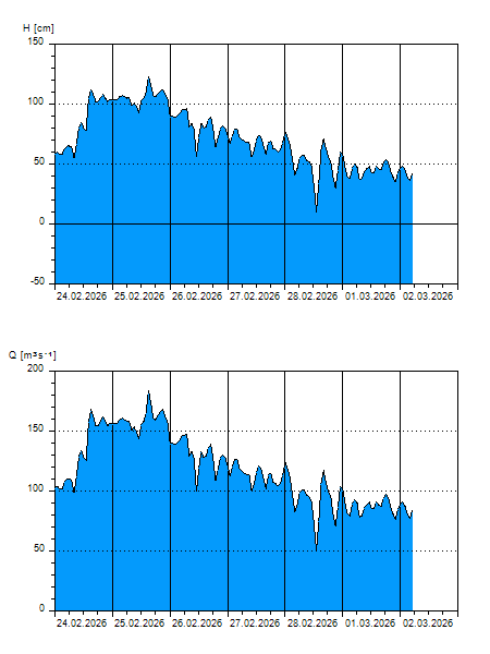
H
[cm]
|
Q
[m3.s-1]
|
QN
|
|
17.06.2026 10:40
| 6 |
53,64
|
|
|
17.06.2026 10:30
| 6 |
53,64
|
|
|
17.06.2026 10:20
| 8 |
55,32
|
|
|
17.06.2026 10:10
| 11 |
57,88
|
|
|
17.06.2026 10:00
| 12 |
58,76
|
|
|
17.06.2026 09:00
| 8 |
55,32
|
|
|
17.06.2026 08:00
| 9 |
56,16
|
|
|
17.06.2026 07:00
| 14 |
60,52
|
|
|
17.06.2026 05:00
| 16 |
62,34
|
|
|
17.06.2026 04:00
| 10 |
57,00
|
|
|
17.06.2026 03:00
| 10 |
57,00
|
|
|
17.06.2026 01:00
| 6 |
53,64
|
|
|
17.06.2026 00:00
| 16 |
62,34
|
|
|
16.06.2026 23:00
| 4 |
52,00
|
|
|
16.06.2026 22:00
| 3 |
51,20
|
|
|
16.06.2026 21:00
| 16 |
62,34
|
|
|
16.06.2026 20:00
| 10 |
57,00
|
|
|
16.06.2026 19:00
| 7 |
54,48
|
|
|
16.06.2026 18:00
| 22 |
68,02
|
|
|
16.06.2026 17:00
| 14 |
60,52
|
|
|
16.06.2026 16:00
| 0 |
48,80
|
|
|
16.06.2026 15:00
| 11 |
57,88
|
|
|
16.06.2026 14:00
| 18 |
64,22
|
|
|
16.06.2026 13:00
| 1 |
49,60
|
|
|
16.06.2026 12:00
| 1 |
49,60
|
|
|
16.06.2026 11:00
| 9 |
56,16
|
|
|
16.06.2026 07:00
| 15 |
61,40
|
|
|
15.06.2026 07:00
| 12 |
58,76
|
|
|
14.06.2026 07:00
| 14 |
60,52
|
|
|
13.06.2026 07:00
| 22 |
68,02
|
|
|
11.06.2026 07:00
| 30 |
76,00
|
|
H — water level
Q — Discharge
QN — QN |