 |
| |
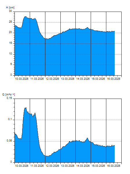
H
[cm]
|
Q
[m3.s-1]
|
QN
|
|
24.06.2026 01:15
| 32 |
0,213
|
|
|
24.06.2026 01:00
| 32 |
0,215
|
|
|
24.06.2026 00:00
| 32 |
0,211
|
|
|
23.06.2026 23:00
| 32 |
0,211
|
|
|
23.06.2026 22:00
| 32 |
0,213
|
|
|
23.06.2026 21:00
| 32 |
0,213
|
|
|
23.06.2026 20:00
| 33 |
0,219
|
|
|
23.06.2026 19:00
| 33 |
0,219
|
|
|
23.06.2026 18:00
| 32 |
0,215
|
|
|
23.06.2026 17:00
| 32 |
0,213
|
|
|
23.06.2026 16:00
| 32 |
0,211
|
|
|
23.06.2026 15:00
| 32 |
0,209
|
|
|
23.06.2026 14:00
| 32 |
0,204
|
|
|
23.06.2026 13:00
| 32 |
0,209
|
|
|
23.06.2026 12:00
| 32 |
0,204
|
|
|
23.06.2026 11:00
| 32 |
0,206
|
|
|
23.06.2026 10:00
| 32 |
0,206
|
|
|
23.06.2026 09:00
| 32 |
0,206
|
|
|
23.06.2026 08:00
| 32 |
0,202
|
|
|
23.06.2026 07:00
| 32 |
0,200
|
|
|
23.06.2026 06:00
| 32 |
0,204
|
|
|
23.06.2026 05:00
| 32 |
0,204
|
|
|
23.06.2026 04:00
| 32 |
0,204
|
|
|
23.06.2026 03:00
| 32 |
0,200
|
|
|
23.06.2026 02:00
| 32 |
0,198
|
|
|
22.06.2026 07:00
| 31 |
0,183
|
|
|
21.06.2026 07:00
| 30 |
0,166
|
|
|
20.06.2026 07:00
| 28 |
0,134
|
|
|
19.06.2026 07:00
| 27 |
0,114
|
|
|
18.06.2026 07:00
| 26 |
0,095
|
|
H — water level
Q — Discharge
QN — QN |