 |
| |
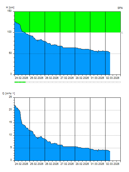
H
[cm]
|
Q
[m3.s-1]
|
QN
|
|
29.06.2026 03:20
| 18 |
0,324
|
|
|
29.06.2026 03:10
| 18 |
0,324
|
|
|
29.06.2026 03:00
| 18 |
0,324
|
|
|
29.06.2026 02:00
| 17 |
0,293
|
|
|
29.06.2026 01:00
| 11 |
0,136
|
|
|
29.06.2026 00:00
| 18 |
0,324
|
|
|
28.06.2026 23:00
| 15 |
0,232
|
|
|
28.06.2026 22:00
| 12 |
0,160
|
|
|
28.06.2026 21:00
| 19 |
0,354
|
|
|
28.06.2026 20:00
| 18 |
0,324
|
|
|
28.06.2026 19:00
| 12 |
0,160
|
|
|
28.06.2026 18:00
| 19 |
0,354
|
|
|
28.06.2026 17:00
| 20 |
0,385
|
|
|
28.06.2026 16:00
| 12 |
0,160
|
|
|
28.06.2026 15:00
| 11 |
0,136
|
|
|
28.06.2026 14:00
| 13 |
0,184
|
|
|
28.06.2026 13:00
| 19 |
0,354
|
|
|
28.06.2026 12:00
| 11 |
0,136
|
|
|
28.06.2026 11:00
| 12 |
0,160
|
|
|
28.06.2026 10:00
| 19 |
0,354
|
|
|
28.06.2026 09:00
| 13 |
0,184
|
|
|
28.06.2026 08:00
| 11 |
0,136
|
|
|
28.06.2026 07:00
| 14 |
0,208
|
|
|
28.06.2026 06:00
| 18 |
0,324
|
|
|
28.06.2026 05:00
| 11 |
0,136
|
|
|
28.06.2026 04:00
| 18 |
0,324
|
|
|
27.06.2026 07:00
| 15 |
0,232
|
|
|
26.06.2026 07:00
| 17 |
0,293
|
|
|
25.06.2026 07:00
| 18 |
0,324
|
|
|
24.06.2026 07:00
| 15 |
0,232
|
|
|
23.06.2026 07:00
| 11 |
0,136
|
|
H — water level
Q — Discharge
QN — QN |