 |
| |
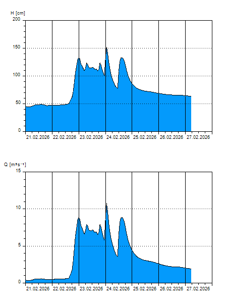
H
[cm]
|
Q
[m3.s-1]
|
QN
|
|
29.07.2026 05:45
| 38 |
0,170
|
|
|
29.07.2026 05:30
| 38 |
0,170
|
|
|
29.07.2026 05:15
| 39 |
0,172
|
|
|
29.07.2026 05:00
| 39 |
0,172
|
|
|
29.07.2026 04:00
| 39 |
0,173
|
|
|
29.07.2026 03:00
| 39 |
0,175
|
|
|
29.07.2026 02:00
| 39 |
0,176
|
|
|
29.07.2026 01:00
| 39 |
0,179
|
|
|
29.07.2026 00:00
| 39 |
0,181
|
|
|
28.07.2026 23:00
| 39 |
0,182
|
|
|
28.07.2026 22:00
| 39 |
0,184
|
|
|
28.07.2026 21:00
| 39 |
0,185
|
|
|
28.07.2026 20:00
| 40 |
0,187
|
|
|
28.07.2026 19:00
| 40 |
0,187
|
|
|
28.07.2026 18:00
| 40 |
0,187
|
|
|
28.07.2026 17:00
| 40 |
0,188
|
|
|
28.07.2026 16:00
| 40 |
0,187
|
|
|
28.07.2026 15:00
| 40 |
0,187
|
|
|
28.07.2026 14:00
| 39 |
0,185
|
|
|
28.07.2026 13:00
| 39 |
0,185
|
|
|
28.07.2026 12:00
| 39 |
0,184
|
|
|
28.07.2026 11:00
| 39 |
0,182
|
|
|
28.07.2026 10:00
| 39 |
0,182
|
|
|
28.07.2026 09:00
| 39 |
0,182
|
|
|
28.07.2026 08:00
| 39 |
0,182
|
|
|
28.07.2026 07:00
| 39 |
0,182
|
|
|
28.07.2026 06:00
| 39 |
0,184
|
|
|
27.07.2026 07:00
| 39 |
0,172
|
|
|
26.07.2026 07:00
| 39 |
0,176
|
|
|
24.07.2026 07:00
| 43 |
0,297
|
|
|
23.07.2026 07:00
| 39 |
0,181
|
|
H — water level
Q — Discharge
QN — QN |