 |
| |
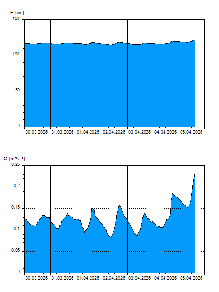
H
[cm]
|
Q
[m3.s-1]
|
QN
|
|
09.04.2026 10:00
| 117 |
0,130
|
|
|
09.04.2026 09:00
| 117 |
0,130
|
|
|
09.04.2026 08:00
| 117 |
0,124
|
|
|
09.04.2026 07:00
| 117 |
0,130
|
|
|
09.04.2026 06:00
| 117 |
0,136
|
|
|
09.04.2026 05:00
| 118 |
0,144
|
|
|
09.04.2026 04:00
| 118 |
0,148
|
|
|
09.04.2026 03:00
| 118 |
0,152
|
|
|
09.04.2026 02:00
| 119 |
0,160
|
|
|
09.04.2026 01:00
| 118 |
0,158
|
|
|
09.04.2026 00:00
| 118 |
0,158
|
|
|
08.04.2026 23:00
| 119 |
0,166
|
|
|
08.04.2026 22:00
| 119 |
0,170
|
|
|
08.04.2026 21:00
| 119 |
0,172
|
|
|
08.04.2026 20:00
| 119 |
0,172
|
|
|
08.04.2026 19:00
| 119 |
0,176
|
|
|
08.04.2026 18:00
| 120 |
0,184
|
|
|
08.04.2026 17:00
| 120 |
0,195
|
|
|
08.04.2026 16:00
| 120 |
0,197
|
|
|
08.04.2026 15:00
| 120 |
0,192
|
|
|
08.04.2026 14:00
| 120 |
0,186
|
|
|
08.04.2026 13:00
| 119 |
0,170
|
|
|
08.04.2026 12:00
| 118 |
0,154
|
|
|
08.04.2026 11:00
| 118 |
0,140
|
|
|
08.04.2026 07:00
| 117 |
0,132
|
|
|
07.04.2026 07:00
| 118 |
0,156
|
|
|
06.04.2026 07:00
| 120 |
0,184
|
|
|
05.04.2026 07:00
| 118 |
0,154
|
|
|
04.04.2026 07:00
| 116 |
0,105
|
|
|
03.04.2026 07:00
| 115 |
0,091
|
|
H — water level
Q — Discharge
QN — QN |