 |
| |
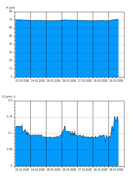
H
[cm]
|
Q
[m3.s-1]
|
QN
|
|
05.04.2026 16:00
| 72 |
0,174
|
|
|
05.04.2026 15:00
| 71 |
0,169
|
|
|
05.04.2026 14:00
| 71 |
0,158
|
|
|
05.04.2026 13:00
| 71 |
0,148
|
|
|
05.04.2026 12:00
| 71 |
0,158
|
|
|
05.04.2026 11:00
| 71 |
0,153
|
|
|
05.04.2026 10:00
| 71 |
0,143
|
|
|
05.04.2026 09:00
| 71 |
0,143
|
|
|
05.04.2026 08:00
| 71 |
0,128
|
|
|
05.04.2026 07:00
| 71 |
0,153
|
|
|
05.04.2026 06:00
| 71 |
0,148
|
|
|
05.04.2026 05:00
| 71 |
0,153
|
|
|
05.04.2026 04:00
| 71 |
0,143
|
|
|
05.04.2026 03:00
| 71 |
0,138
|
|
|
05.04.2026 02:00
| 71 |
0,143
|
|
|
05.04.2026 01:00
| 71 |
0,138
|
|
|
05.04.2026 00:00
| 71 |
0,153
|
|
|
04.04.2026 23:00
| 71 |
0,153
|
|
|
04.04.2026 22:00
| 71 |
0,138
|
|
|
04.04.2026 21:00
| 71 |
0,148
|
|
|
04.04.2026 20:00
| 71 |
0,169
|
|
|
04.04.2026 19:00
| 71 |
0,153
|
|
|
04.04.2026 18:00
| 72 |
0,174
|
|
|
04.04.2026 17:00
| 71 |
0,169
|
|
|
04.04.2026 07:00
| 71 |
0,138
|
|
|
03.04.2026 07:00
| 71 |
0,148
|
|
|
02.04.2026 07:00
| 71 |
0,153
|
|
|
01.04.2026 07:00
| 72 |
0,184
|
|
|
31.03.2026 07:00
| 72 |
0,194
|
|
|
30.03.2026 07:00
| 71 |
0,143
|
|
H — water level
Q — Discharge
QN — QN |