Water Levels and Discharges  |  Reservoirs  |  Precipitation  |  Water quality Last site revision 27.10.2026 10:12
             
Water Levels and Discharges CAUTION: All data are without validation 27.10.2026 10:17:14
 Station  Železný Brod  River  Jizera
Floods
1st level of flood emergency  1st level of flood emergency  220[cm]
2nd level of flood emergency  2nd level of flood emergency  310[cm]
3rd level of flood emergency  3rd level of flood emergency  370[cm]
State of extreme flood  3rd level of flood emergency  (!State of extreme flood) (Q50)546[cm]
RemarkStanice ČHMÚ
low flow rates
low flow rates Q355:3,380 [m3.s-1]
QN [m3.s-1]
Q1Q2Q5Q10Q20Q50Q100
170,0233,0325,0400,0479,0590,0680,0
 Historical floods (3 highest recorded for a period of observation)
09.08.1978636,0 [m3.s-1] N ~50-100
09.03.2000555,0 [m3.s-1] N ~50
13.08.2002433,0 [m3.s-1] N ~10-20
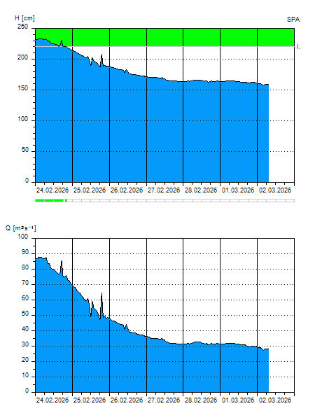
Graf
  H [cm]
Q [m3.s-1]
QN
27.10.2026 10:00 125 10,90
27.10.2026 09:00 129 12,58
27.10.2026 08:00 127 11,74
27.10.2026 07:00 117 7,874
27.10.2026 06:00 121 9,348
27.10.2026 05:00 126 11,32
27.10.2026 04:00 127 11,74
27.10.2026 03:00 126 11,32
27.10.2026 01:00 130 13,00
27.10.2026 00:00 130 13,00
26.10.2026 19:00 134 14,84
26.10.2026 18:00 134 14,84
26.10.2026 16:00 136 15,80
26.10.2026 13:00 142 18,88
26.10.2026 11:00 147 21,58
26.10.2026 07:00 143 19,42
25.10.2026 07:00 100 2,930
24.10.2026 07:00 107 4,614
23.10.2026 07:00 104 3,826
22.10.2026 07:00 107 4,614
21.10.2026 07:00 100 2,930
H — water level
Q — Discharge
QN — QN
 Cross Section
Přícný profil
This information is also available through the application for mobile phones with Android OS (only in the Czech language)  Water Levels and Discharges
  Povodí Labe, státní podnik © 2026 The system uses also data from measuring stations of   Czech Hydrometeorological Institute © 2026 Application developed by   MGE Data s.r.o. © 1996 - 2020