 |
| |
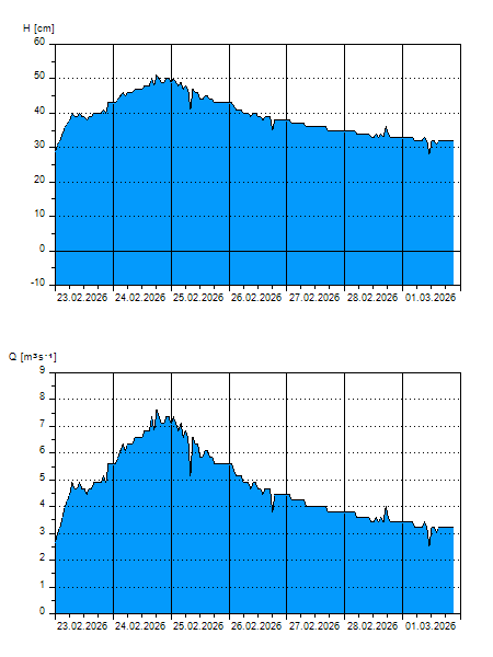
H
[cm]
|
Q
[m3.s-1]
|
QN
|
|
15.07.2026 06:30
| 63 |
11,00
|
|
|
15.07.2026 06:20
| 61 |
10,40
|
|
|
15.07.2026 06:10
| 54 |
8,422
|
|
|
15.07.2026 06:00
| 40 |
4,900
|
|
|
15.07.2026 05:00
| 23 |
1,826
|
|
|
15.07.2026 04:00
| 19 |
1,368
|
|
|
15.07.2026 03:00
| 16 |
1,091
|
|
|
15.07.2026 02:00
| 17 |
1,183
|
|
|
15.07.2026 01:00
| 18 |
1,276
|
|
|
15.07.2026 00:00
| 20 |
1,460
|
|
|
14.07.2026 23:00
| 20 |
1,460
|
|
|
14.07.2026 22:00
| 20 |
1,460
|
|
|
14.07.2026 21:00
| 22 |
1,704
|
|
|
14.07.2026 20:00
| 24 |
1,948
|
|
|
14.07.2026 19:00
| 25 |
2,070
|
|
|
14.07.2026 18:00
| 28 |
2,538
|
|
|
14.07.2026 17:00
| 39 |
4,680
|
|
|
14.07.2026 16:00
| 35 |
3,800
|
|
|
14.07.2026 15:00
| 21 |
1,582
|
|
|
14.07.2026 14:00
| 21 |
1,582
|
|
|
14.07.2026 13:00
| 11 |
0,720
|
|
|
14.07.2026 12:00
| 11 |
0,720
|
|
|
14.07.2026 11:00
| 11 |
0,720
|
|
|
14.07.2026 10:00
| 11 |
0,720
|
|
|
14.07.2026 09:00
| 11 |
0,720
|
|
|
14.07.2026 08:00
| 11 |
0,720
|
|
|
14.07.2026 07:00
| 11 |
0,720
|
|
|
13.07.2026 07:00
| 11 |
0,720
|
|
|
12.07.2026 07:00
| 11 |
0,720
|
|
|
11.07.2026 07:00
| 11 |
0,720
|
|
|
10.07.2026 07:00
| 11 |
0,720
|
|
|
09.07.2026 07:00
| 11 |
0,720
|
|
H — water level
Q — Discharge
QN — QN |