 |
| |
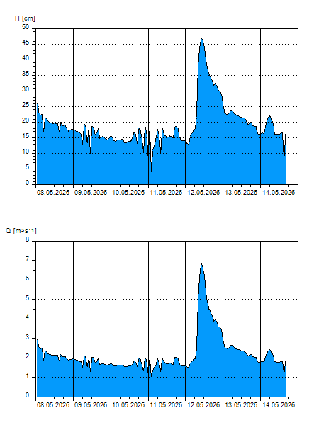
H
[cm]
|
Q
[m3.s-1]
|
QN
|
|
28.07.2026 17:15
| 27 |
3,175
|
|
|
28.07.2026 17:00
| 28 |
3,190
|
|
|
28.07.2026 16:00
| 28 |
3,220
|
|
|
28.07.2026 15:00
| 28 |
3,312
|
|
|
28.07.2026 14:00
| 29 |
3,403
|
|
|
28.07.2026 13:00
| 29 |
3,372
|
|
|
28.07.2026 12:00
| 28 |
3,205
|
|
|
28.07.2026 11:00
| 28 |
3,190
|
|
|
28.07.2026 10:00
| 27 |
3,160
|
|
|
28.07.2026 09:00
| 27 |
3,099
|
|
|
28.07.2026 08:00
| 27 |
3,038
|
|
|
28.07.2026 07:00
| 27 |
3,038
|
|
|
28.07.2026 06:00
| 27 |
3,129
|
|
|
28.07.2026 05:00
| 27 |
3,175
|
|
|
28.07.2026 04:00
| 27 |
3,175
|
|
|
28.07.2026 03:00
| 27 |
3,144
|
|
|
28.07.2026 02:00
| 27 |
3,144
|
|
|
28.07.2026 01:00
| 28 |
3,281
|
|
|
28.07.2026 00:00
| 28 |
3,236
|
|
|
27.07.2026 23:00
| 27 |
3,038
|
|
|
27.07.2026 22:00
| 28 |
3,220
|
|
|
27.07.2026 21:00
| 28 |
3,266
|
|
|
27.07.2026 20:00
| 28 |
3,312
|
|
|
27.07.2026 19:00
| 29 |
3,357
|
|
|
27.07.2026 18:00
| 28 |
3,281
|
|
|
27.07.2026 07:00
| 27 |
3,129
|
|
|
26.07.2026 07:00
| 27 |
3,129
|
|
|
24.07.2026 07:00
| 27 |
3,175
|
|
|
23.07.2026 07:00
| 27 |
3,160
|
|
|
22.07.2026 07:00
| 11 |
1,347
|
|
H — water level
Q — Discharge
QN — QN |