 |
| |
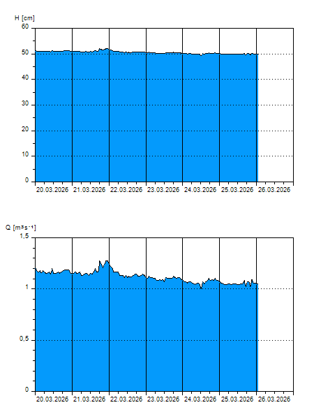
H
[cm]
|
Q
[m3.s-1]
|
QN
|
|
28.06.2026 15:00
| 42 |
0,534
|
|
|
28.06.2026 14:00
| 42 |
0,522
|
|
|
28.06.2026 13:00
| 42 |
0,534
|
|
|
28.06.2026 12:00
| 42 |
0,534
|
|
|
28.06.2026 11:00
| 42 |
0,539
|
|
|
28.06.2026 10:00
| 42 |
0,528
|
|
|
28.06.2026 09:00
| 42 |
0,522
|
|
|
28.06.2026 08:00
| 42 |
0,528
|
|
|
28.06.2026 07:00
| 42 |
0,528
|
|
|
28.06.2026 06:00
| 42 |
0,516
|
|
|
28.06.2026 05:00
| 42 |
0,510
|
|
|
28.06.2026 04:00
| 42 |
0,510
|
|
|
28.06.2026 03:00
| 42 |
0,510
|
|
|
28.06.2026 02:00
| 42 |
0,510
|
|
|
28.06.2026 01:00
| 42 |
0,510
|
|
|
28.06.2026 00:00
| 42 |
0,504
|
|
|
27.06.2026 23:00
| 42 |
0,510
|
|
|
27.06.2026 22:00
| 42 |
0,504
|
|
|
27.06.2026 21:00
| 42 |
0,510
|
|
|
27.06.2026 20:00
| 42 |
0,504
|
|
|
27.06.2026 19:00
| 42 |
0,516
|
|
|
27.06.2026 18:00
| 42 |
0,510
|
|
|
27.06.2026 17:00
| 42 |
0,516
|
|
|
27.06.2026 16:00
| 42 |
0,534
|
|
|
27.06.2026 07:00
| 43 |
0,563
|
|
|
26.06.2026 07:00
| 43 |
0,586
|
|
|
25.06.2026 07:00
| 43 |
0,610
|
|
|
24.06.2026 07:00
| 44 |
0,633
|
|
|
23.06.2026 07:00
| 44 |
0,668
|
|
|
22.06.2026 07:00
| 45 |
0,691
|
|
H — water level
Q — Discharge
QN — QN |