 |
| |
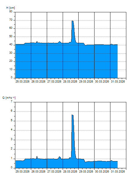
H
[cm]
|
Q
[m3.s-1]
|
QN
|
|
05.04.2026 15:30
| 42 |
0,865
|
|
|
05.04.2026 15:20
| 41 |
0,803
|
|
|
05.04.2026 15:00
| 41 |
0,812
|
|
|
05.04.2026 14:00
| 41 |
0,807
|
|
|
05.04.2026 13:00
| 41 |
0,820
|
|
|
05.04.2026 11:00
| 42 |
0,881
|
|
|
05.04.2026 10:00
| 42 |
0,880
|
|
|
05.04.2026 09:00
| 42 |
0,878
|
|
|
05.04.2026 08:00
| 42 |
0,891
|
|
|
05.04.2026 07:00
| 42 |
0,883
|
|
|
05.04.2026 05:00
| 41 |
0,841
|
|
|
05.04.2026 03:00
| 42 |
0,886
|
|
|
05.04.2026 01:00
| 42 |
0,915
|
|
|
05.04.2026 00:00
| 42 |
0,920
|
|
|
04.04.2026 23:00
| 42 |
0,915
|
|
|
04.04.2026 22:00
| 42 |
0,881
|
|
|
04.04.2026 21:00
| 42 |
0,876
|
|
|
04.04.2026 20:00
| 42 |
0,879
|
|
|
04.04.2026 17:00
| 42 |
0,873
|
|
|
04.04.2026 16:00
| 42 |
0,875
|
|
|
04.04.2026 07:00
| 42 |
0,878
|
|
|
03.04.2026 07:00
| 42 |
0,912
|
|
|
02.04.2026 07:00
| 42 |
0,897
|
|
|
01.04.2026 07:00
| 43 |
1,008
|
|
|
31.03.2026 07:00
| 41 |
0,733
|
|
|
30.03.2026 07:00
| 41 |
0,772
|
|
H — water level
Q — Discharge
QN — QN |