 |
| |
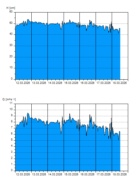
H
[cm]
|
Q
[m3.s-1]
|
QN
|
|
05.04.2026 16:00
| 35 |
3,532
|
|
|
05.04.2026 15:00
| 37 |
3,917
|
|
|
05.04.2026 14:00
| 34 |
3,456
|
|
|
05.04.2026 13:00
| 34 |
3,439
|
|
|
05.04.2026 12:00
| 35 |
3,568
|
|
|
05.04.2026 11:00
| 34 |
3,443
|
|
|
05.04.2026 10:00
| 35 |
3,573
|
|
|
05.04.2026 09:00
| 35 |
3,473
|
|
|
05.04.2026 08:00
| 35 |
3,540
|
|
|
05.04.2026 07:00
| 35 |
3,475
|
|
|
05.04.2026 06:00
| 35 |
3,584
|
|
|
05.04.2026 05:00
| 36 |
3,820
|
|
|
05.04.2026 04:00
| 35 |
3,482
|
|
|
05.04.2026 03:00
| 30 |
2,727
|
|
|
05.04.2026 02:00
| 35 |
3,663
|
|
|
05.04.2026 01:00
| 36 |
3,881
|
|
|
05.04.2026 00:00
| 36 |
3,749
|
|
|
04.04.2026 23:00
| 35 |
3,656
|
|
|
04.04.2026 22:00
| 35 |
3,544
|
|
|
04.04.2026 21:00
| 35 |
3,496
|
|
|
04.04.2026 20:00
| 34 |
3,345
|
|
|
04.04.2026 19:00
| 33 |
3,174
|
|
|
04.04.2026 18:00
| 35 |
3,517
|
|
|
04.04.2026 17:00
| 37 |
3,921
|
|
|
04.04.2026 07:00
| 35 |
3,572
|
|
|
03.04.2026 07:00
| 35 |
3,546
|
|
|
02.04.2026 07:00
| 35 |
3,599
|
|
|
01.04.2026 07:00
| 36 |
3,792
|
|
|
31.03.2026 07:00
| 37 |
3,958
|
|
|
30.03.2026 07:00
| 37 |
4,104
|
|
H — water level
Q — Discharge
QN — QN |