 |
| |
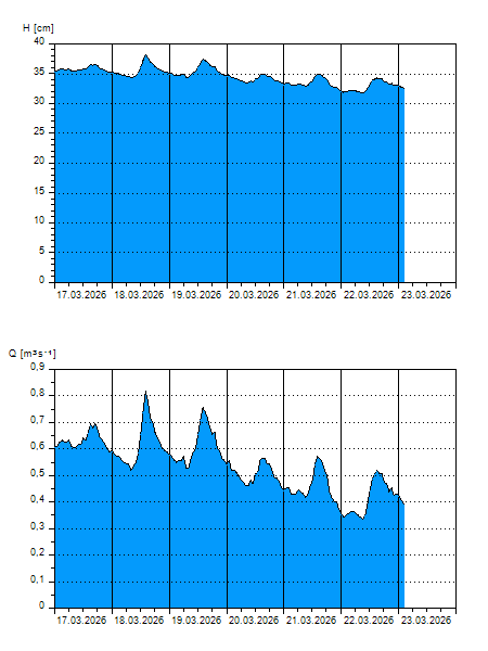
H
[cm]
|
Q
[m3.s-1]
|
QN
|
|
09.04.2026 11:15
| 27 |
0,219
|
|
|
09.04.2026 11:00
| 27 |
0,218
|
|
|
09.04.2026 10:00
| 26 |
0,214
|
|
|
09.04.2026 09:00
| 26 |
0,213
|
|
|
09.04.2026 08:00
| 27 |
0,217
|
|
|
09.04.2026 07:00
| 26 |
0,216
|
|
|
09.04.2026 06:00
| 27 |
0,217
|
|
|
09.04.2026 05:00
| 27 |
0,217
|
|
|
09.04.2026 04:00
| 27 |
0,221
|
|
|
09.04.2026 03:00
| 27 |
0,223
|
|
|
09.04.2026 02:00
| 27 |
0,225
|
|
|
09.04.2026 01:00
| 27 |
0,229
|
|
|
09.04.2026 00:00
| 27 |
0,229
|
|
|
08.04.2026 23:00
| 28 |
0,234
|
|
|
08.04.2026 22:00
| 28 |
0,237
|
|
|
08.04.2026 21:00
| 28 |
0,238
|
|
|
08.04.2026 20:00
| 29 |
0,246
|
|
|
08.04.2026 19:00
| 29 |
0,254
|
|
|
08.04.2026 18:00
| 30 |
0,260
|
|
|
08.04.2026 17:00
| 31 |
0,271
|
|
|
08.04.2026 16:00
| 31 |
0,275
|
|
|
08.04.2026 15:00
| 31 |
0,298
|
|
|
08.04.2026 14:00
| 31 |
0,269
|
|
|
08.04.2026 13:00
| 30 |
0,259
|
|
|
08.04.2026 12:00
| 28 |
0,242
|
|
|
08.04.2026 07:00
| 26 |
0,210
|
|
|
07.04.2026 07:00
| 27 |
0,229
|
|
|
06.04.2026 07:00
| 31 |
0,291
|
|
|
05.04.2026 07:00
| 31 |
0,276
|
|
|
04.04.2026 07:00
| 31 |
0,273
|
|
|
03.04.2026 07:00
| 30 |
0,258
|
|
H — water level
Q — Discharge
QN — QN |