 |
| |
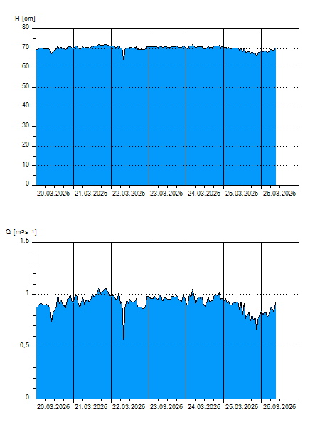
H
[cm]
|
Q
[m3.s-1]
|
QN
|
|
07.04.2026 10:30
| 62 |
0,495
|
|
|
07.04.2026 10:20
| 62 |
0,500
|
|
|
07.04.2026 10:10
| 62 |
0,464
|
|
|
07.04.2026 10:00
| 62 |
0,462
|
|
|
07.04.2026 09:00
| 62 |
0,487
|
|
|
07.04.2026 08:00
| 62 |
0,492
|
|
|
07.04.2026 07:00
| 62 |
0,500
|
|
|
07.04.2026 06:00
| 62 |
0,479
|
|
|
07.04.2026 05:00
| 62 |
0,469
|
|
|
07.04.2026 04:00
| 62 |
0,473
|
|
|
07.04.2026 03:00
| 62 |
0,469
|
|
|
07.04.2026 02:00
| 62 |
0,468
|
|
|
07.04.2026 01:00
| 62 |
0,469
|
|
|
07.04.2026 00:00
| 62 |
0,470
|
|
|
06.04.2026 23:00
| 62 |
0,466
|
|
|
06.04.2026 22:00
| 62 |
0,471
|
|
|
06.04.2026 21:00
| 62 |
0,488
|
|
|
06.04.2026 20:00
| 62 |
0,488
|
|
|
06.04.2026 19:00
| 62 |
0,486
|
|
|
06.04.2026 18:00
| 63 |
0,508
|
|
|
06.04.2026 17:00
| 63 |
0,507
|
|
|
06.04.2026 15:00
| 62 |
0,492
|
|
|
06.04.2026 14:00
| 62 |
0,471
|
|
|
06.04.2026 13:00
| 62 |
0,501
|
|
|
06.04.2026 12:00
| 63 |
0,518
|
|
|
06.04.2026 11:00
| 63 |
0,526
|
|
|
06.04.2026 07:00
| 62 |
0,501
|
|
|
05.04.2026 07:00
| 63 |
0,545
|
|
|
04.04.2026 07:00
| 63 |
0,516
|
|
|
03.04.2026 07:00
| 64 |
0,591
|
|
|
02.04.2026 07:00
| 66 |
0,668
|
|
|
01.04.2026 07:00
| 66 |
0,702
|
|
H — water level
Q — Discharge
QN — QN |