 |
| |
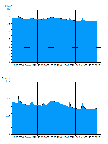
H
[cm]
|
Q
[m3.s-1]
|
QN
|
|
05.04.2026 16:00
| 31 |
0,103
|
|
|
05.04.2026 15:00
| 31 |
0,107
|
|
|
05.04.2026 14:00
| 31 |
0,106
|
|
|
05.04.2026 13:00
| 31 |
0,107
|
|
|
05.04.2026 12:00
| 31 |
0,111
|
|
|
05.04.2026 11:00
| 31 |
0,102
|
|
|
05.04.2026 10:00
| 30 |
0,095
|
|
|
05.04.2026 09:00
| 30 |
0,095
|
|
|
05.04.2026 08:00
| 30 |
0,094
|
|
|
05.04.2026 07:00
| 30 |
0,094
|
|
|
05.04.2026 06:00
| 30 |
0,094
|
|
|
05.04.2026 05:00
| 30 |
0,094
|
|
|
05.04.2026 04:00
| 30 |
0,095
|
|
|
05.04.2026 03:00
| 30 |
0,095
|
|
|
05.04.2026 02:00
| 30 |
0,095
|
|
|
05.04.2026 01:00
| 30 |
0,095
|
|
|
05.04.2026 00:00
| 30 |
0,096
|
|
|
04.04.2026 23:00
| 30 |
0,095
|
|
|
04.04.2026 22:00
| 30 |
0,094
|
|
|
04.04.2026 21:00
| 30 |
0,093
|
|
|
04.04.2026 20:00
| 30 |
0,092
|
|
|
04.04.2026 19:00
| 29 |
0,090
|
|
|
04.04.2026 18:00
| 29 |
0,088
|
|
|
04.04.2026 17:00
| 29 |
0,090
|
|
|
04.04.2026 07:00
| 29 |
0,082
|
|
|
03.04.2026 07:00
| 29 |
0,088
|
|
|
02.04.2026 07:00
| 29 |
0,084
|
|
|
01.04.2026 07:00
| 27 |
0,070
|
|
|
31.03.2026 07:00
| 27 |
0,070
|
|
|
30.03.2026 07:00
| 27 |
0,072
|
|
H — water level
Q — Discharge
QN — QN |