 |
| |
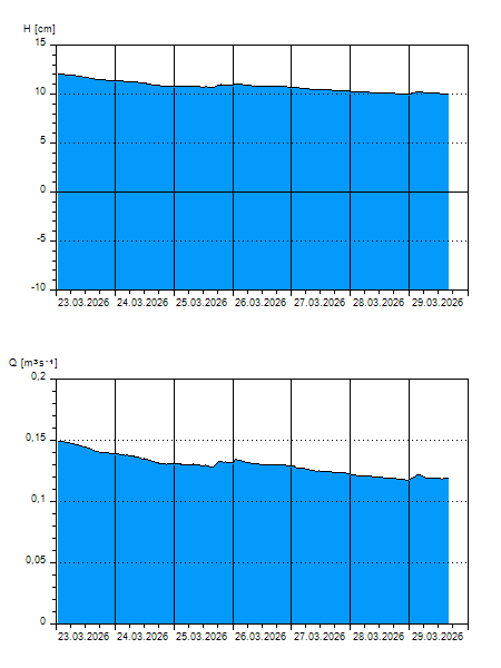
H
[cm]
|
Q
[m3.s-1]
|
QN
|
|
05.04.2026 16:00
| 18 |
0,253
|
|
|
05.04.2026 15:00
| 17 |
0,242
|
|
|
05.04.2026 14:00
| 17 |
0,232
|
|
|
05.04.2026 13:00
| 17 |
0,225
|
|
|
05.04.2026 12:00
| 16 |
0,219
|
|
|
05.04.2026 11:00
| 16 |
0,214
|
|
|
05.04.2026 10:00
| 16 |
0,213
|
|
|
05.04.2026 09:00
| 16 |
0,211
|
|
|
05.04.2026 08:00
| 16 |
0,210
|
|
|
05.04.2026 07:00
| 16 |
0,209
|
|
|
05.04.2026 06:00
| 16 |
0,208
|
|
|
05.04.2026 05:00
| 16 |
0,207
|
|
|
05.04.2026 04:00
| 16 |
0,206
|
|
|
05.04.2026 03:00
| 15 |
0,203
|
|
|
05.04.2026 02:00
| 15 |
0,200
|
|
|
05.04.2026 01:00
| 15 |
0,197
|
|
|
05.04.2026 00:00
| 15 |
0,194
|
|
|
04.04.2026 23:00
| 15 |
0,189
|
|
|
04.04.2026 22:00
| 14 |
0,184
|
|
|
04.04.2026 21:00
| 14 |
0,181
|
|
|
04.04.2026 20:00
| 14 |
0,174
|
|
|
04.04.2026 19:00
| 13 |
0,169
|
|
|
04.04.2026 18:00
| 13 |
0,165
|
|
|
04.04.2026 17:00
| 13 |
0,160
|
|
|
04.04.2026 07:00
| 12 |
0,145
|
|
|
03.04.2026 07:00
| 12 |
0,150
|
|
|
02.04.2026 07:00
| 11 |
0,140
|
|
|
01.04.2026 07:00
| 10 |
0,116
|
|
|
31.03.2026 07:00
| 10 |
0,118
|
|
|
30.03.2026 07:00
| 10 |
0,120
|
|
H — water level
Q — Discharge
QN — QN |